|
| An evil plan, to an evil place…wasn’t always thus. But the witches came and came, and soured the Earth. Save for a few decent sorts, and in the end…well. |
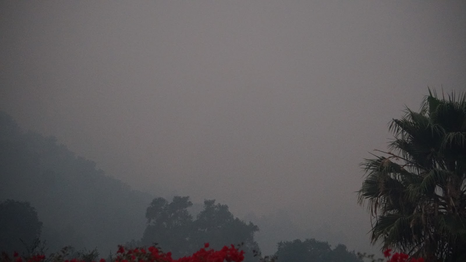
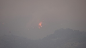
This blog will be updated hourly today, but I have to evacuate and before that, go back into the fire to rescue someone’s animals and belongings. It seems that although the fire already swept through the area once in eastern Ojai, suspicious fresh new burns are starting up again in those sections that weren’t burned down the first time. Thank you all for your prayers and kind thoughts.
Like Northern California, Southern California-or So Cal- is the beneficiary of a very evil plan to remove people from the countryside, hinterlands, mountains, and anywhere that people have their own wells, propane tanks, and arable land for growing.
MONDAY NIGHT
It all started Monday, December 4th, at 2 in the afternoon. I was outside, which has an overlook of highway 33 and I watched as 2 miles worth of pumper trucks that the firemen use, head out of town. I had never seen so many fire trucks at one time, except on the news or internet. I literally said, something is up, but I see no smoke anywhere nor have heard about a fire anywhere. 2 PM Monday, remember that. at 9PM they turned off the power to both Ventura and Santa Barbara counties for 13 hours. This trapped many people, and created complete traffic jams that went for miles in every direction, on every main road.
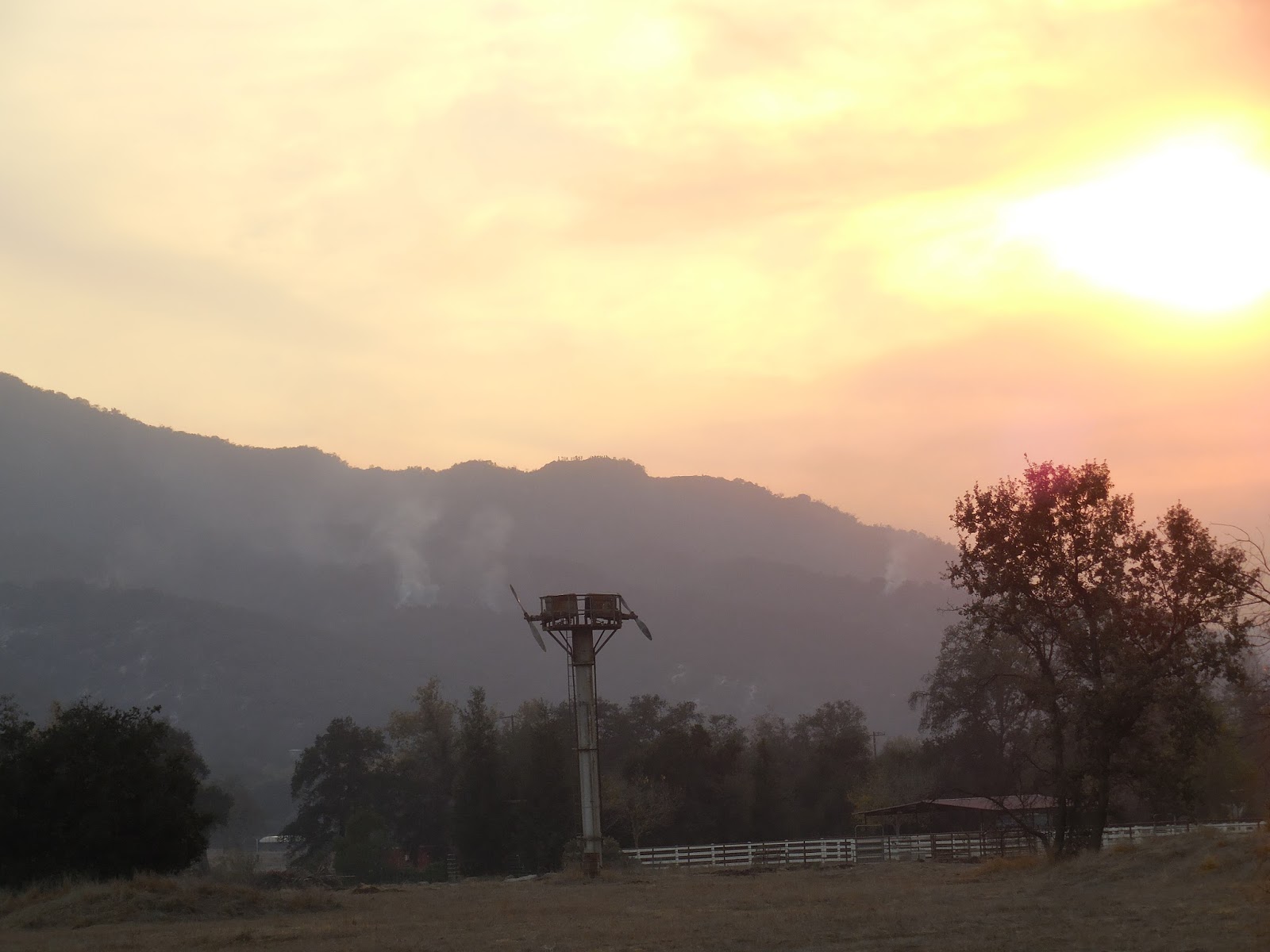
Then, at 6:15PM on Monday, there were initial reports of a fire at the Devil’s hole location at the Saint Thomas Aquinas Seminary school, run by Jesuits and adjacent to an NSA listening post with many large scale dishes and DUMB. There is where they say the fire started. The very first fire of hundreds that would appear all at once within the same 24 hours spread over an area the size of France.
I know all this because I live in the middle of all this and have spent all week doing rescues, evacuating, and watching fires roar through the mountains that ring Ojai Valley without any planes, helicopters, or fire fighting personnel or equipment anywhere to be seen. ALL week, except for one small enclave where EX POLICE, FIREMEN, AND FEDERAL AGENTS LIVE IN RETIREMENT. THAT ONE LITTLE AREA GOT ALL THE EQUIPMENT AND ALL THE PRISON LABOR TO DO THE ACTUAL FIRE FIGHTING THAT OUR WAY OVERPAID FIREMEN NEVER DO, BECAUSE IT IS SO DANGEROUS. That enclave on Encino road was protected, but everywhere else from Fillmore to the ocean and from the Los Padres national forest to Carpenteria was just left to burn.
And I have the proof, as you will see.
Even now, as I write this at 4am Thursday, December 7th, the fires are ringing our home in a circle all burning ferociously and nothing is being done to stop them. At all. Thousands of homes and 50,000 people so far have been burned out of their land and homes. And, as the EPA instituted a little obscure rule with the Forest Service a few years back, once an EPA designated habitat area is destroyed, the land reverts to the Federal government and the people cannot rebuild. They lose everything to the government. As is happening.
 |
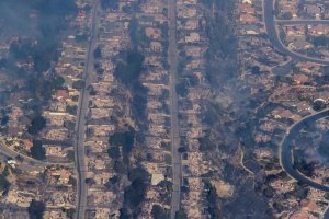
| Everything that says burn scar is completely destroyed homes, land, farms. |
I know this because I was in a field at the furthest end of Ojai Valley Wednesday morning, as over 16 battalion command cars came by the field I was filming in, taking pictures of the land they did nothing to protect and of me. And these were forest service personnel and Fire chiefs. Doing nothing, but they DID HAVE huge cameras and all they did was talk on the phone and take pictures of everything that had been destroyed. They seemed most interested in any surviving structures, of which a friend of mine’s home DID survive, when all the others around her for two miles in any direction were burned to the ground. Oh yes, they were very interested in her home.
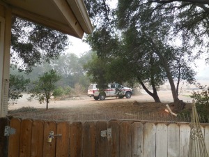 |
| One of 16 such fire chiefs of both ventura county firemen and forest service, come to inspect our little standing house, in the midst of devastation in every direction. 16 within 40 minutes, and all different guys, by the license plate numbers we observed. Prayer saved this home, as son Matthew and I at 5am Tuesday stood in her living room as we were rushing to get her out as the flames were within 100 feet of her in three directions and ask Yahuah, our Father, to allow this home to be unharmed. It was. And is. So far. Because it looked like they wanted to fire the place. And now, they have created roadblocks so we cannot come in and feed her chickens or check on the house. These are satanists, who do such things. |
TUESDAY 12-5-17
 |
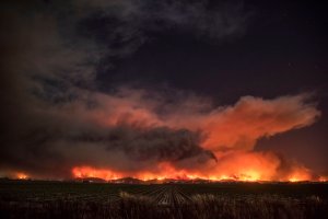
| The firestorm moving at a speed of 100 feet per second |
 |
| We had to rescue a dear lady who lived alone in the country, while this wall of fire closed in on us from every direction |
 |
| Safely back at home, later Tuesday morning, we could see burns in every direction of the valley north, east, and south. This view is to the west. |
 |
| sunrise Tuesday morning, no firetrucks anywhere and we WERE EVERYWHERE the fire was. Taken from Ojai ave 6am,on our way to get someone out of an area that was burning. We came across police roadblocks, so we have to take dirt roads behind the regular roads and as we got near our destination, yet another sheriff stopped us, telling us everyone behind had been evacuated. We informed his that was impossible, as we had just spoken to the lady, who was 300 yards from his roadblock. He let us through, and then ALL OF US, found our cell phones had been disabled after that and we could not call or message anyone. |
Mandatory Evacuations on Tuesday morning
- Ventura Ave from Canada Larga to Foster Road
- Creek Rd at Ventura St.
- Creek Rd north to Camp Comfort
- Ventura St North to Montgomery
- Creek Rd south of Camp Comfort
- Persimen Hill
- Norweign Track
- Casitas Springs
- McAndrew Rd, Thatcher Rd, Canada Rd, Reeves Rd
- Foster Park
- In Santa Paula, everything east of Say Rd to the north city limits
- SR 150 W. of Peck north of Virginia Terrace
- Foothill, Telegraph and Ashwood Hill
- County Inn Estates mobile home park at Wells and Telegraph
- Encino Rd (where we live)
- Alto Rd
- Feliz Rd
- Thatcher School
- La Conchita and Emma Woods State Beach area
- All of Rancho Vista Rd north of Foothill from road closure
- 4 miles of Hwy 150 north of Hwy 101
- Grand Ave to Carne Rd
- Reeves Rd to Carne Rd
- All of Casitas Pass Rd
DO NOT DONATE MONEY TO THE RED CROSS OR OFFICIAL ORGS, WHICH WERE SETUP BEFORE THE FIRE. IF YOU KNOW SOMEONE WHO IS IN A BURN ZONE, DONATE OR HELP THEM ON A CASE BY CASE BASIS. AT LEAST THEY WILL GET THE HELP. BIG DONATION PITCHES BY OFFICIAL GROUPS AND THE MONEY GOES INTO A BLACK HOLE, THE PEOPLE NEVER SEE A DIME OF HELP.
THURSDAY MORNING 12-6-7
 |
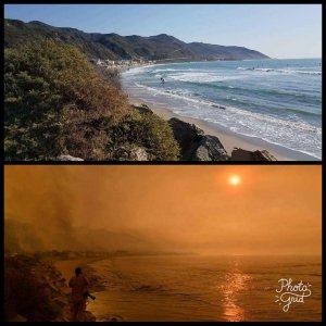
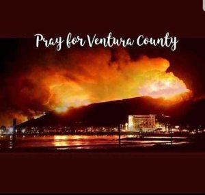
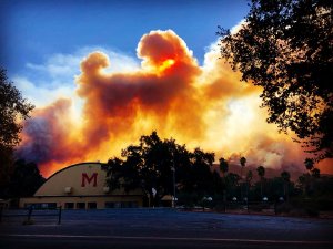
| Coastal range firestorm, mostly hidden by smoke. This firestorm runs the entire length of our view of it. And starting at the beach tuesday evening, is now heading into Ojai Valley, taking out scores of homes ranches, farms, orchards. And as we can see and hear, nothing is being done to stop it. |
 |
| Spoke to a lady doing a rescue of animals in River Bottom, the lowest, western section of Ojai valley. She says the frestorm is 15 miles wide, has come down the mountain range, and is descending upon the valley at the NOW DRY Ojai River. And she reports no fire trucks, personnel or anything abouts to fight the fire. As we’ve seen all week, save for the elite section of Ojai Tuesday night. Also, Someone actually donated 25 bucks to help. Thanks Eric. I promise to use to help all involved, as we’ve taken in folks and they are still ordering us to leave, we’d rather wait until the flames are at the door. It also appears, that someone is going around firing various areas starting new burns too far from existing firewalls, and only in country settings. Like NorCal. It’s our turn. |
You’re prayers are most gratefully received, God Bless You all, you decent souls.
Thursday Night 12-7-17
First, in memory of Uncle John John, as Mom called him – Battleship California, killed Pearl harbor

 |
| The California took several direct hits, throwing many sailors overboard, like John |

 |
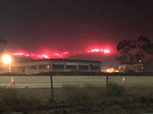
| Firestorm, finally come at us from the west tonight, two miles away. After a week of rescues, evacutions, missing fire crews, and NO helicopters or planes, now this. |
 |
| A wall of fire tonight 12 miles long, heading our way. Sorry for the shaky picture, shot it freehand in dense smoke. |
 |
| This is actually a wall of fire coming down from wheeler springs and now, they say, Meiner’s Oaks is burning in River bottom. THe entire ocean range from main street ventura to Summerland is now gone. so much for a nice place to live or is that the point? |
 |
| We are in the middle of the reverse C |
 |
| our lovely coastal range, a wasteland now |
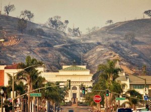 |
| City Hall…no more homes in the hills |
 |
| Why this happened…no more people in the mountains and hills |
 |
| We chose to stay, see it through. Looking back, over last five days of this horror show in our laps, glad we did. Lives and animals were saved by it. Trusting in the Father gives all good things. |
 |
| A rescue done Tuesday morning and the aftermath the next day, the entire ridge and all those homes destroyed. Save the few where we were only. Odd that. There is a house behind this view, of which a dear lady was saved, happily. Police tried to stop us from coming in, saying all were evacuated, at this very spot, when I knew better and told him so. Of course she was at her home, waiting for us to come. Then they turned off all our cell phones. |
 |
| Everywhere you go, away from the fire, is patches of burn that make no sense. |
 |
| Pristine, and most beautiful creek road, now a wasteland. We watched them, as we live nearly on it, do nothing as the flames swept down the mountain and took out everything. No planes, no helos, no firetrucks. Just battalion commanders standing around. |
Frankly, all week, the only people we saw were just regular folks, putting themselves in harm”s way, helping people get out. No firemen or police were doing such work. Not until Thursday night, did we see them finally go into action…with prison labor. Also, we have helo shots of them finally at 3pm Thursday, getting buckets of water from lake Casitas and doing drops up wheeler canyon.
 |
| Finally, 3pm Thursday, the whole empire that is fire fighting swings into action with everything they have and the boys prove what could have saved 200,000 acres, countless homes, and many lives, had this been turned on Monday night, Early Tuesday at the latest. Division strength personnel, when you add in prison labor, and whammo, the wall of fire in Western Ojai get bombed into non-existence. |
 |
| Strange blue light… |
Another little fun feature of this fire and ongoing, is the turning off of the power for 12 hours at a stretch, making it near impossible to open garage doors, see what you are doing in the dark, etc. And always where folks need rescuing. No one seems to be asking these questions on any twitter feed or anything. It’s all THANKYOU MISTER FIREMAN shite…really. I didn’t see them on the edges of the blaze all week, just tards like us…I did see, though, lots of prison labor trucks moving around the valley, the guys theyACTUALLY PUT ON THE FIRE LINE IN FRONT OF 100 FOOT FLAMES. and when that passes, regular firemen, putting out smoldering embers.
 |
| Firemen putting out some embers in a field, far away from the fireline, where nothing is around to burn. What could burn here, already did, in east end. I’m sure they have their reasons, just given the necessity of these guys being on the frontlines, being in the rear with the gear makes no sense. There is no brush or structures anywhere near this spot. We had to hike through a mile of forest to get to a house, to save the animals of a house, the day before. |
 |
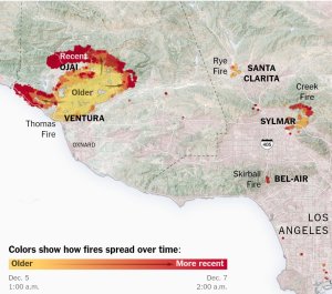
| current burn map 128-17 we are at the star. it’s in error. the map. the two ends of the C have connected in a circle and are moving EAST towards us. |
Here comes the sunrise…there is a wall of fire in front of us to the west. Can’t see it because of smoke density, but we know its there. If practicable, will up date further.
ANY FILM OR PICS OF FIREMEN IN RED UNIFORMS IS PRISON LABOR, DOLLAR A DAY FOR RISKING THEIR LIFE. THE YELLOW SUITED GUYS ARE ACTUAL, HIGHLY PAID FIREMEN.
 |
| Prison labor, dollar a day, ON THE FIRE LINE. |
 |
| Fillmore, Lake Piru, all those country farms and homes…gone |
 |
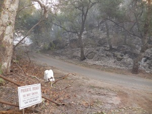
| It is NOT illegal. Afraid we might see something? |
 |
| Everytime the fire is out, it springs up again from another direction. |
 |
| Downtown Ojai…DEMON in fire. Look in flames, it’s there. All of these fires are being hexed. And all are ARSON. Think about it. All the country settings from San Diego to Santa Barbara, burning all at once and at the same time. Fires left to burn, taking out entire communities, with perfect regularity? That’s no accident. |
Visibility at our place, 50 feet, air unbreathable, even with masks. friday 730am 12-8-17
Nevai, Donna, bless your hearts.
A reader asks about the EPA thingy taking land back from the people. Here was my answer
it was on an EPA site we found a few years ago, because in helping a friend find a home out here, we kept running into maps that said, EPA zone 5. And, two years ago, the lady we rescued had forest personnel all over her place and she was, WHAT ARE YOU DOING?
THIS IS NOW FOREST LAND, AND UNDER OUR PROTECTION AS A HABITAT.
Then she was ignored. All we could find was this obscure EPA rule. I didn’t download it, but it’s out there.
 |
| A fire unstopped…tearing through the countryside, town after town. |
 |
| Indeed |
 |
| All of Upper Ojai, a rather large and old section of Ojai Valley, is completely incinerated. |
RED CROSS…getting millions…just leaving stacks of fluoridated water battles at the end of streets. Oh, and taking well posed pics for more money. As well, there are now HUNDREDS of organized go fund me and patreon deals for money, mostly from people having nothing to do with the fire and using other’s pictures for graft. It’s sickening.
 |
| No planes, no helos, no fire personnel… |
NO WIND TODAY OR YESTERDAY…so no excuses about the planes or choppers not flying.
SEE LINK REVEALING FIREMEN STARTING FIRES IN NEW AREAS, NOT BACK BURN. AS THESE FIRE STARTS ARE IN HEAVILY WOODED AND POPULATED AREAS WITH MANY HOMES AND SMALL ORCHARD RANCHES, AS IN THE CASE BELOW. I know East Valley Road very well, and it is the high road, also known as state highway 192, above Santa Barbara. Which, of course, is burning now. Wonder how that fire started?
https://youtu.be/SPjipjZtE2w
 |
| Fire already destroyed this Nordhoff range of mountains at this location, but on Thursday afternoon, right in front of me, a new burn exploded, right where buildings that survived the first time around, were standing. Wish I had a drone with Go Pro level camera on it, I’d use it. |
It’s Friday evening and the fires still burn. In carpenteria, Los Padres Forest, Fillmore, Lake Piru, Moorpark, ALL THE CHANNEL ISLANDS-HOW DID THAT HAPPEN, THEY ARE 20 MILES AWAY IN THE OCEAN? And on and on… The smoke has been so dense all day that visibility is about 100 feet in any direction. I’ve been wearing a bandanna to breathe, but…. I and we are most grateful for the spiritual and other support. Your kind words and thoughts are received happily. It’s like a boost that helps push through the long days. And this week has been a trying one. I’ve lived through many natural disasters, but this firestorm has beaten all the others I’ve dealt with. The one in January 2000, 2007 SCV, etc. The Northridge earthquake, and others.
These were satanic affairs, as they love marking their work with many tells. This one is, as disasters go, a big one. It has and will continue to affect, some 2 million lives, long after the fires are gone. Lives will change forever. People have died and will die. Lies are being told as truths, by the same old liars in the media, govt, and organized bureaucrat crime syndicates, known as the county and state business mafia.
 |
| Strange Blue Light in moutains above Fillmore BEFORE they burned |
 |
| Some of the boys, starting new burns. Dumping their tanks on city roads, which is illegal because of the chemicals. We witnessed them do that yesterday, Thursday 12-7-17 |
We all read of terrible events that affect the world. And many of us have had to live through them, giving us a keener empathy and understanding when it happens to others. We know what it is like to be in danger, to save others from danger, and to see the very people we count on to do their job and save the situation not only make it worse, but in fact, create the danger to begin with. And these thugs are highly paid monsters who always want more, play the victim, and act the hero. And they are none.
You all are the hero. In your own ways, your kindness, and empathy. Those in the mess, know their duty. Do what you can, always. Be strong for the weak and panicky. And Pray for guidance and fortitude. That’s the thing. And to see love come your way, even when NOT asked for, is such a wonderful blessing. Big hugs and kisses to you all.
Thanks Pam, you angel of the Pacific, for being there…
THIS IS ALL ABOUT AGENDA 21-2030
UPDATE 12-9-17
We are still here and okay. Quite a week, with many close calls for us and others. So many were not so lucky. I actually saw people on ridges point at the fire and laughing. Satanic shites. These monsters are in love with death.
 |
| Ventura, LA, Santa Barbara counties…so far |
 |
| Weather balloon type sat pics of the area, as of Thursday…nothing current |
 |
CLICK TO ENLARGE
This map does not show the destruction of Moorpark, Simi Valley, nor that the fire has moved eastward into Piru Lke area. Like all Official maps, they UNDER represent the truth of things, for they have no truth in them. |
 |
Matilda Junior High School
A nice, well behaved model and integrated community of Anglo and Hispanic, erased. Moorpark and West Simi, has always been what integration of cultures should and can be. Always. To fire this fine example of most excellent non-racist residences, is just wrong. But they did. Instead the satanic left agents of chaos try to turn races against each other, creating death and destruction. Moorpark and Simi has been since the 1960s, an ideal place to raise a family and is highly moral. The ladies are ladies and the young girls act and are, virtuous women worth dating and marrying. Oh well… |
 |
| Above Ojai, Highway 33 |
 |
| Fillmore from Moorpark and Simi Valley, yesterday…It has now moved another 5 miles east taking out the most beautiful drive in Los Angeles County, the 126 corridor |
 |
| No one loves me, I’m all alone, They set fire to our homes. Dear Father, in your hands I commend my Spirit. |
All the video footage the network TV shows, is mostly from Monday night, the Santa Paula start of the fire. They under report and I’ve caught them in countless lies and disinformation. Be warned.
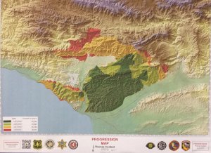 |
| Official fire map. Where is the Moorpark SImi devestation and the wall of fire that came from Lake Casitas through Summerland? Those fires are still out of control and should be RIGHT NOW red areas. I guess they have their reasons for keeping the map a LIE. |
 |
| Fire Fighters get free meals everywhere they go…the rest of us, we get fluoridated bottled water dumped off on the corner, if that. You’d think with the millions the RED CROSS is raking in on the Thomas Fire, they could do a little more for us. Guess not. We lose our homes and community, the yellow suit fire guys get triple time, plus combat pay, plus extra bonuses for herding prison labor around and putting out embers from fires mostly finished in an area, from what we’ve seen. To be fair, I’ve also seen yellow suits throwing down big time on fires, especially when news crews and journalists-so called-are around. The red suits get nothing–Shit meals, fluoridated water bottles, and yellow suits keeping an eye on them. Doesn’t seem equitable or fair, does it? Because it isn’t. Residents are on their own, other than the kindness of strangers. When you talk to the law or yellow suits, they talk down to you, unless you flash the badge, than you are treated like an old buddy. I’ve seen it, so… |
 |
| Thomas fire, from Nordhoff ridge, just after the firestorm passed through last night |
 |
| Weather balloon sat pics, and always a few days old, though this is “official” Saturday morning release |
You’d think, after a solid week of this, it would over by now. But no. The smoke today is getting denser, the fires are raging to the west and north, out of control. And all of us are just burned out by this whole thing. A nice lady gave me a hospital mask yesterday, for being out and about. Was near a ridge that was burning on the 33 highway and fire trucks were leaving. the whole area was wiped out. Sorry no pics, too smoky and night.
 |
| choking on the smoke. Where is Santa Barbara and Carpenteria in all this? |
Yesterday afternoon, we drove through the burn areas in the west around Lake Casitas to the 150 highway. Everything was dead out, thanks to the helos they deployed Thursday night. Now, this morning, that entire line is on fire again, as we posted Thursday night, this morning. How is that possible? There are no current burns in that area, because the fire has moved deep into the Los Padres, over the mountains tot the north, and into Santa Barbara, 30 miles to the west. Now, the wall of fire, a few miles away to the west is back with a vengeance. 2 hours ago, nothing. Now, a wall of fire. These people ARE STARTING THE FIRES. Here is your proof.
https://youtu.be/SPjipjZtE2w
 |
| The fire helos back at it. When the FF machine is turned on with a purpose, they knock these fires down FAST. And well done. But, when the order is stand down, entire counties are scorched earth. Way it is, when Agenda 21 is the bible of your ops. |
 |
| Have chopper, will stop fire |
 |
| visibility and air quality the worst ever. My throat is as raw as can be. But honey, tea, and bandannas keep things in check |
 |
| A new burn, 2pm 12-9-17, that wasn’t there an hour ago, and was put out, in that area, 2 days ago. And all along a five mile front. 20 miles from the current firestorm. Someone is playing with flame throwers. I have the footage. |
https://youtu.be/SPjipjZtE2w
Thank you Catherine, for your kindness. The rescues and field work continue. Adrenalin like candy daily, while in the mix of things. But, this research and truth won’t come by itself. If any of you have something which will give the truth of things on this, send it on or send the link. I’ll use it.
Saturday, 3PM, 12-9-17
So, Nathan and I go do a rekky (recon) down creek road, the entire length and breadth of Ojai, and River bottom. As we were heading eastward, it was smoky but no fires to be seen. An hour later, as the sun was setting,we back tracked on the very same route and the entire place was ablaze. Sulfur mountain-which burned down both sides on Tuesday, was complete ablaze, wherever there was an ACCESS ROAD, AND NEAR THOSE HOUSES THAT DIDN’T BURN THE FIRST TIME ON TUESDAY. Nordhoff range, which completely burnt down on wednesday and Thursday, then headed north, SAME THING. Finally, in the west, the entire range from Meiner’s oaks to the coast range was again, ablaze on ground that had ALREADY SEEN A FIRESTORM COME THROUGH, A FEW DAYS AGO.
Wow. Remember the video of the yellow suit guys starting fires? Right.
So, I mention this at the gas station, and right off, network assets immediately cover for the operation with “oh, its just back burn.” Back burn to what? The fire already swept through those mountains and had moved along, miles and miles away to burn down new areas four days ago. I told her that, and she just stared at me with hate. Then every other person at the station repeated what she said. Again, I told them. “I just drove up and down the 150 highway in Ojai valley, all the fires STARTED AT THE EXACT SAME TIME, AS IF ON CUE.” Then you get that hate filled stupid look. The satanists going along, to control the narrative.
“I have video and picture proof of this happening. You know. YOu people can lie all you want, but I’m going to expose you.” This blog post is that exposure. I’ve not found anyone else doing this in realtime. Sure, later, someone will blather about it. But for now, its just us.
Then we drove by this place called camp comfort, filled with hundreds of yellow suits and their fire trucks, having a bbQ while this is going on and drinking beer.
I rest my case.
Here is the proof.
 |
| heading out, eastward, along Ojai Ave…a single smoke plume, but not line of flames. Makes sense, the whole range went up in smoke on Tuesday, from end to end. |
 |
| Heading back, westerly on Ojai Ave, and tada! A line of fires appear all at once, the entire length of the mountain to the south of the valley. All in the same five minutes. This is where houses stand that survived the the Tuesday horror show of destruction. Any sign of fire trucks, or sirens? Not a single one, nothing. Sorry for the spirit beam, these things show up in my pics alot, I usually throw them away, but, need the shot. |
 |
| More of the same line. Again, only those places that didn’t burn and in which a few surviving homes are…or were…now. Sorry for the spirit beam, these things show up in my pics alot, I usually throw them away, but, need the shot. They’re more than harmless, they serve YHVH as messengers. |
 |
| Footage of just one small part of that line of fires, dozens of them that spread over miles, that all started at once. |
|
 |
| Just think, five minutes before no flames, no smoke, just a burned out mountain silent as a grave, as it has been since Tuesday. |
 |
| It’s all happening so fast, very fast. No time to get out. The flame throwers are working overtime on this arson work, and from fire roads that take them near surviving structures |
 |
| Same story in the west, as we head south down Highway 33, a line of fires that weren’t there when we headed north an hour before. |
 |
| More along the same line in the west |
 |
| And the same, more of the advancing line of death to the houses you see in the foreground. In the distance, are small ranches that survived thursday, as we saw on Yesterday’s rekky. Now, up in smoke they go, all at once. Just a coincidence I’m sure. |
 |
| again, the line to the west continues as more fire starts start up one after another as the fire crews creep southward along fire roads along surviving homes. |
 |
| creek road, mentioned days ago. oh well |
 |
| more creek road. |
Mandatory Evacuations Santa Barbara County:
- The area of Highway 192 on the south,
- Highway 150 on the east (county line),
- Casitas Pass Road to the west and extending north to East Camino Cielo at Hwy 154
[youtube https://www.youtube.com/watch?v=nYxfsGutVTk] As can be seen in above video, the fire from the west, is AGAIN, a mere 1 mile away from us, two days later, even though yesterday afternoon, it was already out from the ocean to Wheeler springs, by burning the area to the ground. As reported from other recorded fires from sunset on, this area too is now alive with fire, even though the nearest fire in the west, IS OVER 20 MILES AWAY.
So…how did a 12 mile stretch of fire line appear out of nowhere, as it has done everywhere in the valley. It’s like reliving Tuesday through Thursday, but time wise, a great deal more condensed.
Sigh…
MIDNIGHT 12-10-17 THE POWER HAS BEEN TURNED OFF IN SANTA BARBARA COUNTY, AS THE FIRE SPREADS RAPIDLY AMONG THE HILLS AND HOMES.
This is a common feature of this fire, as seen elsewhere…whenever the fire of any of these SoCal fires starts eating into communities, they cut the power, making evacuation with goods and possessions nigh impossible for residents. Bastardos.
 |
| The hills above Summerland and Carp, 1an Sunday |
 |
| Current fire map. Not much left of Ojai, Oak View, Casitas Springs, Miramonte, Upper Ojai. We are in a ring of death. Sunday morning 2am |
 |
| The fire half mile away in the west. You can feel the heat. |
 |
| Fire at Lake Casitas, where a D.U.M.B. IS LOCATED IN THE SOUTH OF THE LAKE. |
All hotels, motels, etc, are fully booked in a 200 mile radius. All these evacuees had to go somewhere. Was a time you could just camp out in a national forest, but that’s a felony now, thanks to Agenda 21. And if you have a campfire, the fines and jail time are severe, as a forest service lesbian told me a few years ago.
 |
| Everything in red is allegedly fire…not so, all of Ojai Valley is burning again. The little area in the middle has been arsoned again by the fire bastards. Once again, we find ourselves in the middle of the furnace. As was stated earlier, most maps put out by the network are lies to deceive. |
 |
| What? To start more fires and do nothing but drive around getting free meals? |